|
Historic Preservation in Princeton Township
A Brief History of Princeton |
Early Roads And Boundries
The recorded history of the Princeton area began in the late 17th century when European travelers crossed the narrow "waist" of New Jersey between the Delaware and Raritan rivers along paths created by the Lenni Lenape Indians. Portions of these paths survive in present day Nassau and Stockton Streets, Princeton-Kingston Road, Princeton-Lawrenceville Road, and Mount Lucas Road. One former path became the King's Highway and central New Jersey's main road for well over a hundred years.
In 1683 a New Englander named Henry Greenland built a house on the highway which is believed to be the first by a European within the present Township boundaries. He opened it as a "house of accommodation" or tavern. Portions of this house survive within the Gulick House at 1082 Princeton-Kingston Road. Around 1685 Greenland's son-in-law, Daniel Brinson, settled along the highway on the land where the house known as "the Barracks" stands at 32 Edgehill Street.
East Jersey and West Jersey representatives met in 1683 at Greenland's tavern to establish their common boundary. George Keith, a prominent Quaker, surveyed what became known as the "Keith line", which also became the boundaries of several Counties and Townships, including the western border of Princeton Township in East Jersey. In the 18th century settlers developed the "province line" into roads in several places, including portions of the present Province Line Road. East Jersey prop 'rietors established four counties in 1683, including Middlesex County which extended to the province line and included the Princeton area as part of Piscataway Township. In 1688 the proprietors created Somerset County which included the northern portions of the Princeton area.
The Original Quaker Settlement
In the 1690's six Quaker families established a community along Stony Brook near the King's Highway (Route 206). Benjamin Clarke was the first to purchase 1,200 acres with the best meadow and the longest possible frontage along the stream. A list of Piscataway taxpayers around 1700 includes all the families - Clarke, Olden, Stockton. The Stony Brook settlers built a landing in 1707 and a grist mill in 1712-14. Land was given for the Friends Meeting in 1709 and a meeting house was built in 1724.
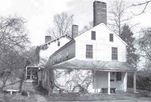
Gulick Farm house - original section c. 1683
Kingston Mill Historic District
In 1710 Somerset County was redefined to include the northern portion of the Township's land area under its jurisdiction. In 1714 the boundary between Middlesex and Somerset counties was established along a portion of the old road (Nassau Street) "leading toward the falls of Delaware (Trenton), so far as the eastern division of this province extends" (Snyder) and along Harry's Brook. A portion of the main thoroughfare of Princeton thus separated two counties, as Route 27 in Kingston does today.
"Princeton" and the College of New Jersey
The name "Princeton" appeared in 1724 and became common about ten years later. When the colonial post riders began using the King's Highway a village with a tavern trade sprang up. By 1740 regular stage traffic was operating, and by 1745 the well known Dalley map of the King's Highway showed that the new village had eclipsed the Stony Brook settlement and had become an important landmark between New Brunswick and Trenton.
In 1756 the College of New Jersey moved from Newark and erected Nassau Hall, bringing the village prominence and a strong Presbyterian influence. The village initially clustered around the college - the Stockton family of Morven thought of themselves as living "near" the village rather than in it. Princetonians Richard Stockton, John Witherspoon and Joseph Hewes were
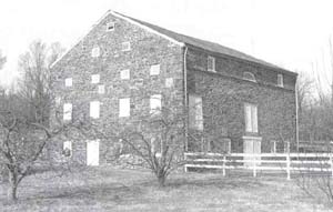
Tusculum Barn - built c. 1830
signers of the Declaration of Independence, ( Hewes from his subsequent residence in North Carolina). The Battle of Princeton in January of 1777 was recognized as a turning point in the Revolutionary War and made Princeton famous. From June to November 1783 the Second Continental Congress met in Princeton and brought America's new leaders to town. The new State Legislature also met at Princeton.
The Two Princetons
Following the Revolutionary War a number of citizens tried to persuade the Legislature to incorporate Princeton as a Township-sized municipality, but the effort failed due to the objections of Stony Brook residents. Instead the Borough of Princeton was subsequently created in 1813 with boundaries similar to the present ones. At that time boroughs existed as subordinate governing units within Townships and were not autonomous as they are today. Boroughs were responsible for some municipal tasks and could raise taxes for certain services, but Townships still provided many services in the Boroughs. In 1838 Mercer County and Princeton Township were both established. Although this brought both sides of Nassau Street into the same county for the first time since 1714, the Borough remained divided between two Townships - West Windsor and Princeton. In 1843 West Windsor yielded some of its land south of Nassau Street to Princeton Township, and in 1853 it yielded the rest of its land between the Delaware and Raritan Canal and Nassau Street. The Borough became fully autonomous in 1894.
A 19th Century Construction Boom
Increased traffic through the area led to the construction in 1804 of the "straight turnpike" (Route 1) between Trenton and New Brunswick, which drew stage traffic away from Princeton. In 1807 the construction of the Princeton-Kingston Branch Turnpike (Mercer Road-Mercer Street-Nassau Street-Princeton-Kingston Road) helped to restore some of the lost activity. In 1811 the Presbyterian Church established Princeton Theological Seminary and in 1815 built Alexander Hall.
The construction of the Delaware and Raritan Canal and the Camden and Amboy Railroad in the 1830's stimulated considerable development in many areas along the route, including Princeton. With the construction of Princeton Basin as a shipping terminus and Canal Road (Alexander Street) linking it to the Borough, coal and building industries began to flourish in this area. The construction boom continued with the erection of Whig and Clio Halls at the College, Miller Chapel at the Seminary, and the new First Presbyterian Church. Charles Smith Olden built the central porticoed block
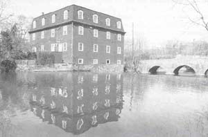
Kingston Mill - built c. 1888
Kingston Historic District
of Drumthwacket with a fortune he brought home from New Orleans. It was the era of the Greek Revival, and each of these buildings adhered closely to the Greek temple form. Charles Steadman and other builders erected dozens of new houses, including the highly prized collection at the top of Alexander Road which combined elements from the Federal and the Greek Revival styles.
The major buildings of the 1840's and 50's were designed by Philadelphia architects in Picturesque Revival styles. The influential architect John Notman designed four imposing villas for Commodore Stockton and his relatives, including Prospect, Guernsey Hall, Springdale, and the Walter Lowrie House, plus a church, a parish school, and the restoration and modification of Nassau Hall. By the mid?nineteenth century, fashionable society with its fine architecture and large estates had become concentrated on the westerly side of the town.
Princeton University and Residential Growth
After the Civil War the College launched an aggressive building campaign that has continued to the present. During the presidency of James McCosh (1868-88), the college erected buildings in primarily the Victorian Gothic style. There was a brief period of construction in the Richardsonian Romanesque style, most notably the college's Alexander Hall. At its Sesquicentennial in 1896 when the college officially became Princeton University, it announced that the Collegiate Gothic style would be used for future campus buildings. During the next fifty years, twenty-seven University buildings were erected in this style. The campus expanded to the corner of Nassau Street and University Place, along the east side of University Place and along both sides of Washington Road.
As the college expanded, so did residential development. In the last quarter of the 19th century many large houses were built on Dickinson Street, University Place, and Bayard Lane. This was a period of great eclecticism in architecture. After the First World War developers began to create subdivisions with a relatively limited choice of house designs. With exceptions on Prospect Avenue, and in a few other places, the eastern end of the Borough and most of the Township continued to be developed in more vernacular styles. From Forest-to-Agriculture-to-Housing in the Township While residential growth in the Borough continued at a steady pace, the Township remained agricultural and rural until the 20th century. The 17th century wilderness that Greenland and the Stony Brook Quakers first found here was a forest of widely varying density with a small portion of open grassland. While the early settlers typically cultivated areas of fifty acres, deforestation was an annual chore for many years. By 1731 the view from the main highway was characterized by farm fields. By the third quarter of the century, newspaper advertisements reported that farmhouses two and three miles to the east had a clear view of Nassau Hall. Nassau Hall is visible from the Stony Brook in pictures by Revolutionary War artists.
By 1800 most of the Township's arable land was in agricultural production or reserved for woodlots for fuel. When coal replaced wood as the main fuel, the reserved lots were cut for timber, leaving much of the Township cleared. Since there was no more uncleared arable land available for new farms, agricultural advancement in the 19th century was dependent on new crops or technology. Some of the large, older farms were subdivided into smaller farms to take advantage of these new opportunities. The canal and the railroad brought new locational advantages, and urban markets quickly developed for special crops, particularly apples and peaches. While many farms prospered, others were unable to adapt to the changes.
Historians of agriculture have noted that farming in New Jersey declined more or less continuously since the 1870's, and this is true in Princeton Township as well. As general farming continued to give way to special crops, marginal farmland was abandoned. Although the hilly areas of the Township were never completely cleared, forests returned to many formerly cultivated areas. By 1890 the owner of Worth's mill, located on the Stony Brook and what is now Route 206, suspended operations. He had operated it as a "convenience" to the neighborhood. Many of the old farm houses became inhabited by tenant-farming families.
By 1900 the Mount Lucas neighborhood was in decline. The small farms in the hilly areas of the Township began to be abandoned. In his history of Mount Lucas, Sylvester referred to the "encroaching" woods, and reported that no self-sufficient small farms were left at Mount Lucas by 1925. The Cedar Grove area, once the home of numerous French emigres, was also partly abandoned early in this century.
For most farmers, agriculture in the Township was not profitable enough to withstand the reward promised by real estate development. In the 1920's and '30's the northwestern section of the Township along the borough line was the first part to become suburbanized. Housing development boomed as postwar employment expanded in Princeton and nearby communities and as commuting to New York became more affordable and practical.